Showing 84 items matching gippsland floods
-
 Orbost & District Historical Society
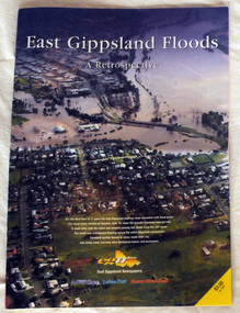
pictorial magazine, East Gippsland Floods A Retrospective, 2007
... East Gippsland Floods A Retrospective...floods-east gippsland disasters-flood... Gippsland flood event in 2007. Photos are of Bairnsdale, Lakes... gippsland pictorial magazine East Gippsland Floods A Retrospective ...This magazine pictorial was produced by East Gippsland News as a record of the Floods of June/July 2007.This is a contemporary record of a local event.A magazine pictorial with photos of the June/July East Gippsland flood event in 2007. Photos are of Bairnsdale, Lakes Entrance, Lake Tyers, Orbost, Linenow, Metung, Eagle Point and Paynesville.floods-east gippsland disasters-flood -
 Orbost & District Historical Society
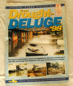
pictorial magazine, From Drought to Deluge '98, 1998
... flood-1998 flood-east gippsland disaster-floods... the East Gippsland Red Cross Flood Appeal. Following heavy rain... Red Cross Flood Appeal. Following heavy rain in East Gippsland ...This magazine cost $2.50 and was produced to support the East Gippsland Red Cross Flood Appeal. Following heavy rain in East Gippsland in June, 1998, major flooding occurred in the Mitchell, Nicholson, Tambo, Snowy, Brodribb and Bemm Rivers. Other streams in the region also experienced high flows during this time. Probably the most severe direct impacts of the floods were to the rural sector.This magazine is a contemporary record of a significant local event.Two copies of a magazine pictorial of the floods of 1998. Photos are black and white. They are of Bairnsdale, Orbost, Lakes Entrance, Raymond Island, Bemm River, Bruthen , Tambo and Cabbage Tree. flood-1998 flood-east gippsland disaster-floods -
 4th/19th Prince of Wales's Light Horse Regiment Unit History Room
Regimental Scrap Book: 1990-1999, 2009
... gippsland floods... PWLH for assistance with flood emergency in Gippsland April... traralgon traralgon army depot commendations gippsland floods Roy ...Archival quality A3 loose leaf slip case containing memorabilia documents, cuttings and photos about the Regiment for the period 1990-1999. Contents include:Training, Ceremonial, social activities. Hansard 18 Oct 1990 re future of the Regiment. Threats to the Regiment. Chief of General Staff Commendation to A Squadron 4/19 PWLH for assistance with flood emergency in Gippsland April 1990. Meritorious Unit Commendation to Prince of Wales Light Horse Troop while attached to 173 US Airborne Brigade, South Vietnam 1965/66. Freedom of City of Melbourne May 1992. 50th Birthday of Regiment. Closure of Traralgon Depot 1998.ceremonial, training, vietnam war, history 4 19 prince of wales s light horse, freedom of city melbourne, freedom of city traralgon, traralgon army depot, commendations, gippsland floods -
 Orbost & District Historical Society
black and white photographs, second half 20th century
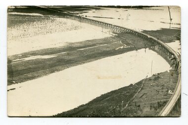
... Orbost-Railway East-Gippsland -Railway Orbost-floods... gippsland black and white photographs Five black / white photographs ...3154.1 is a postcard of the Orbost viaduct over the flooded Snowy River flats. 4153.2 is of a goods train on the viaduct. 3154.3 is of a loaded goods train with the driver at the window. Two men are standing on the plate and there are two workers below where there is some water and flood debris. 3154.4 is of amachine moving flood debris on the rail line. 3154.5 shows flood damage to the viaduct across the Snowy River flats. Two men are driving a dozer.This item is associated with the history of the Orbost-Bairnsdale railway line and therefore reflects the role that the rail line played in the social and economic history of Orbost.Five black / white photographs associated with the Orbost railway line during a flood.orbost-railway east-gippsland -railway orbost-floods -
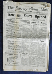
 Orbost & District Historical Society
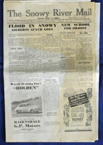
newspaper, 15.2.1950
... family as part of East Gippsland Newspapers. The flood in 1950... gippsland newspaper A Snowy River Mail newspaper dated 15,.2.1950 ...The Snowy River Mail is a weekly newspaper published in Orbost in the Shire of East Gippsland, Victoria, Australia. Previously published as The Snowy River mail and Tambo and Croajingolong gazette from 1890 to 1911. The Gippsland Courier merged with the Snowy River Mail when proprietor Lachlan Ross moved to Orbost in 1910. In 1999 the paper was acquired by the Yeates family when the Hollins family retired from the newspapers business. The paper is still being produced by the fourth generation of the Yeates family as part of East Gippsland Newspapers. The flood in 1950 was a significant Orbost event. This newspaper is a contemporary record of a significant local events.A Snowy River Mail newspaper dated 15,.2.1950. It contains news articles and advertisements in black/white print. There is an artcle about the Orbost floods.newspaper snowy-river-mail flood-1950-orbost -
 Orbost & District Historical Society
newspaper, Snowy River Mail, 29.3.1950
... family as part of East Gippsland Newspapers. The 1950 flood... family as part of East Gippsland Newspapers. The 1950 flood ...The Snowy River Mail is a weekly newspaper published in Orbost in the Shire of East Gippsland, Victoria, Australia. Previously published as The Snowy River mail and Tambo and Croajingolong gazette from 1890 to 1911. The Gippsland Courier merged with the Snowy River Mail when proprietor Lachlan Ross moved to Orbost in 1910. In 1999 the paper was acquired by the Yeates family when the Hollins family retired from the newspapers business. The paper is still being produced by the fourth generation of the Yeates family as part of East Gippsland Newspapers. The 1950 flood was a significant event in Orbost. This newspaper is a contemporary record of a significant local events.A Snowy River Mail newspaper dated 29.3.1950. It contains news articles and advertisements in black/white print. it contains an article on the flood at that time.snowy-river-mail 1950-flood newspaper -
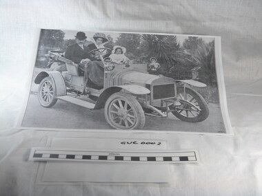 Gippsland Vehicle Collection
Book, Darge, Victoria's Leaders in the Motor Car World, 1911 (estimated); Based on make & models of vehicles, maps, and articles
Book of "Darge" photographs c.1911. Algenon Darge was a noted photographer in Melbourne around the commencement of the 20th century. 124 pages"The property of Bramwell" "thanks Fred" "Fred Armylope\19/7/68"melbourne, melba, dame nellie melba, gippsland, cars, darge, broadbent, road map, advertisements, touring, james flood, hudson, berliet -
 Orbost & District Historical Society
black and white photographs, 1934
These photographs were taken just after the McKillop's Bridge was completed after the flood damage. The current McKillop’s Bridge was built by the Country Roads Board in two stages between 1931-36, during which its height was raised after the original bridge superstructure was washed away in record floods of January 1934, prior to its original official opening. In its reconstructed form the original concrete abutments were turned into additional piers and the welded-steel trusses were cantilevered back over them to meet the new higher road approaches. It is sited at McKillops Crossing, named after pioneer overlanding squatter George McKillop who crossed here in 1835. This was a stock crossing place for almost a century before the bridge was constructed. (info. from Victoria Heritage Register)This is a pictorial record of the history of McKillop's Bridge, in itself of historical significance for its association with Victoria's long and important pastoral history, its technicl significance and aesthetic significance.Three black / white photographs. 3133.1 shows the approach to a washed away bridge. 3133.2 is of a bridge over a river with men clearing debris. 3133.3 is a close-up showing the wreckage of the bridge.mckillop's-bridge snowy-river flood-damage-1934 -
 Orbost & District Historical Society
black and white photograph, mid 1930s
This is a photograph of McKillop's Bridge probably taken just after its rebuilding. The current McKillop’s Bridge was built by the Country Roads Board in two stages between 1931-36, during which its height was raised after the original bridge superstructure was washed away in record floods of January 1934, prior to its original official opening. In its reconstructed form the original concrete abutments were turned into additional piers and the welded-steel trusses were cantilevered back over them to meet the new higher road approaches. "McKillops Bridge was Heritage listed due to its social and technological significance – the steel trusses' arc-welded construction technique was a pretty big deal in the 1930s. It was once an important route for cattlemen, who used the ford across the Snowy in the years preceding the bridge's existence"This is a pictorial record of McKillop's Bridge just after its construction.A black / white photograph of a wooden bridge across a river. At the bottom right is a man with his back to the camera. He is looking at flood debris on the bank. At the bottom left are two men near a pylon.on back - McKillops Bridgebridge-mckillop's snowy-river-bridge -
 Orbost & District Historical Society
May 1900
This is a photograph of the original Orbost / Snowy River Bridge , a suspension bridge which opened in 1893. It has been taken when the Snowy River was in flood. It is similar to other photographs held in The State Library, Victoria. The Snowy River Mail and Tambo and Croajingolong Gazette Sat 12 Aug 1893 records the opening of this bridge as "the most important public event that has yet been commemorated in Eastern ......The Messrs McLeod, with whom the first settlement of this district is generally associated, took up their residence on the eastern bank of the Snowy River about the year 1841 or 42. The late Mr W. Roadknight and Mr T. T. Stirling took possession of the territory on the western side of the Snowy about 35 years ago. During the occupation of the country by cattle owners, very little progress was made in the way of roads and bridges, and except to the hardy and lexperienced bushman, it might have been generally regarded as inaccessible. About the year 1877, however, the late Mr James Robertson eldest son of Mr James Robertson, of Lochend farm, selected land now occupied by his father, about four miles from Orbost on the west bank of the river, Mr John Cameron visited the. district shortly after a .tour of inspection and returned later with his brothers, James and Alick Gameron, but found that during their absence Mr Ernest Watt had found his way on the scene and pegged out a selection, thus anticipating the advent of the Camerons by about 12 hours. We understand that a Mr Kidd, who selected the property now occupied by Mr W. J. Ross, at Pumpkin Point, was one of the earliest batch of settlors.........."This is a pictorial record of an early bridge across the Snowy River at Orbost.A black / white photograph of a suspension bridge with flood waters below the bridge.orbost-bridge suspension-bridge snowy-river -
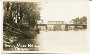 Orbost & District Historical Society
black and white photograph, first half 20th century
This is a photograph of the second Snowy River Bridge at Orbost. The section in the central span could have been built after flood damage. This bridge over the Snowy River was opened on July 4 1922. It was constructed in 1922 alongside the previous suspension bridge. Its building was a combined effort of the Victorian Railways and the Country Roads Board at a cost of 35,000 pounds. It was replaced in 1976 by the present bridge after several major floods.This bridge was replaced in 1976 after several major floods.A black / white photograph / postcard of a bridge over a river. It has what looks like a bo girder in the central section. On the left is the river bank.on front bottom left - "SNOWY RIVER BRIDGE"orbost snowy-river-bridge transport-bridge -
 Orbost & District Historical Society
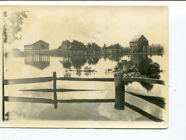
black and white photographs, 1890s
Peter Cameron, came to Orbost in 1885, at the age of 69, having sold his farm at Geelong. Peter bought the property ―Glen Avon from a Mr Street. The home was situated at the bottom of the paddock, near the corner of Morley and Livingstone streets. The farm stretched from Tennyson Street to the end of Snaggers Lane and along the river frontage to “Carinya” Cameron Home. In the Gippsland Times on Wednesday. 2 Jul 1890 on Page 3 is an article titled "THE SNOWY RIVER CALAMITY" which describes an ".unexpectedly sudden rush of water down the flats..... the terrified people commenced to remove their stock from the land and the work of saving property was continued all day ............ many head of cattle were washed away.......The river road, for its entire length, is obliterated, and the approaches to the bridge at Watt's Gulch are gone, with the enormous volume of flood water," These photographs are pictorial records of a significant event in the history of Orbost. There are few personal records of the very early floods.Three black / white photographs of wooden buildings with flood water in foreground. There are post and rail fences. 3193.2 has been taken from a distance.on back -" "Glenavon east of Lagoon 1897 Feb"floods-orbost-1890s glenavon-orbost -
 Orbost & District Historical Society
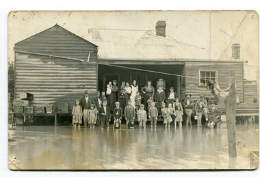
black and white photograph, poss. 1920
In the photograph are the Rice family, Billy Nixon' family and Charlie Johnston. William Nixon, son of James Nixon and Alice (Roberts) Nixon was married to Ilma Muriel (Cadwallader) Nixon on 2 Apr 1902 in Orbost. They had six children - Llewella Adele (Nixon) King, Sydney William Columbo Nixon, Arthur Harry Nixon, Jack Warton Nixon, Claudine Frances (Nixon) Taylor and Daphne Joyce (Nixon) Menz Damage estimated at £500,000 was caused by the 1934 floods in the Orbost district. This 1934 flood was devastating, destroying a section of the 1922 Orbost bridge, wrecking fences, bridges and roads, dumping silt and debris on the rich river flats and drowning cattle. Note: although this card has the date 1934 written onto the rear, the flood incident depicted most likely dates from 1920 (ref. Weekly Times, Saturday 6 March 1920 p 41 when this photo was printed).This item is a pictorial record of a flood in 1920 (ref. Weekly Times, Saturday 6 March 1920 p41). Snowy River flood are a feature of the Orbost area. These floods cover the rich agricultural land. A black / white photograph / postcard of a group of people standing in floodwaters outside a timber building. Included are young children and babies being held by women. Two boys are holding dogs in front of them.on back - "Billy Nixon's house (now Downys 1991)"orbost - floods - nixon - 1920 -
 Orbost & District Historical Society
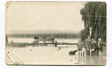
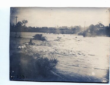
black and white photograph, 1934
This photograph was taken during the flood of 1934 in Orbost. The people in the photograph are related to Billie and Ilma Nixon and Charlie Johnston. Damage estimated at £500,000 was caused by the 1934 floods in the Orbost district. This 1934 flood was devastating, destroying a section of the 1922 Orbost bridge, wrecking fences, bridges and roads, dumping silt and debris on the rich river flats and drowning cattle.This item is a pictorial record of a significant event in Orbost's history. It is associated with local families.A black / white photograph / postcard of floodwaters. On the right is a young man with four young boys sitting on a log. In the bckground is a rowing boat with one man rowing and three others sitting on the edges . A field of maize / corn is in the background and a large willow tree on the right.on back - "M. C. Rice Orbost 19 /1/20 M Gilbert. Mostly Billy Nixons & Charlie Johnstons 1934" [Note alteration: W C Rice rather than M C Rice].floods-orbost-1934 nixon-william johnston-charles -
 Orbost & District Historical Society
black and white photograph, February 1971
This photograph was taken near the Snowy River Bridge on the the old Princes Highway in Orbost, near the caravan park. The 1971 flood was the the worst flood on record. At Jarrahmond it was at least 11 metres and up to one and a half kilometres wide on the flats causing enormous damage to the flood plain. Records say that "The brown floodwater stain in Bass Strait could be seen from passing airliners." Considerable damage was done to railway infrastructure, roads and farms. More information from the APRIL, 2008 newsletter by John Phillips. (see orbosthistory.com.au)This is pictorial evidence of a significant local event. Floods have been an integral part of Orbost's history for hundreds of years.A black / white photograph of debris, fallen power lines, a tree across the highway and floodwaters across the road.on front at bottom - handwritten in upper case print - " 1971 FLOOD PRINCES HIGHWAY NEAR SNOWY BRIDGE"floods-orbost-1971 -
 Orbost & District Historical Society
black and white photograph, February 1971
This photograph is an aerial view of the township of Orbost taken by the Bairnsdale Advertiser newspaper. It was taken from the northern end of the town. The 1971 flood was the the worst flood on record. At Jarrahmond it was at least 11 metres and up to one and a half kilometres wide on the flats causing enormous damage to the flood plain. Records say that "The brown floodwater stain in Bass Strait could be seen from passing airliners." Considerable damage was done to railway infrastructure, roads and farms. More information from the APRIL, 2008 newsletter by John Phillips. (see orbosthistory.com.au)This is a pictorial record of a significant event in the history of Orbost,A black / white aerial photograph of a township with floodwaters in the background.on back - "Note main current through the lagoon 1971."orbost-floods-1971 bairnsdale-advertiser orbost-township -
 Orbost & District Historical Society
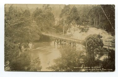
black and white photograph / postcard, Early 20th century - pre 1906?
This photograph shows the Hospital Creek in flood. This is a pictorial record of a bridge in East Gippsland in the early 20th century.A black / white photograph / postcard of a road bridge across a flooded creek. It is in a bush setting.in front at bottom - "Hospital Creek in flood H.D.Bulmer photo Lake Tyers"bridge-hospital-creek tostaree-bridge -
 Orbost & District Historical Society
black and white photographs, 1974 - 1976
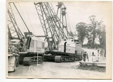
Construction of the roadway embankment between the bridges across the Snowy River flood plains at Orbost commenced in January 1974 and was completed in November 1976. Pearsons were the bridge contractors for the construction of the Princes Freeway and bridges across the river flood plains at Orbost. Heavy rains and floods held up progress.These photographs are of the construction of a major structure in Orbost. The opening of this Snowy River Bridge was an important development in the accessibility to the township of Orbost.Four black / white photographs of construction sites. 3241.1 is of three cranes and other machinery with six persons. 3241.2 is of workmen working on flooded site. 3241.3 is a photograph of the early stages of construction of a bridge looking towards the township. 3241.4 shows the construction of a roadway between the bridges.construction-snowy-river-bridge bridge-orbost -
 Orbost & District Historical Society
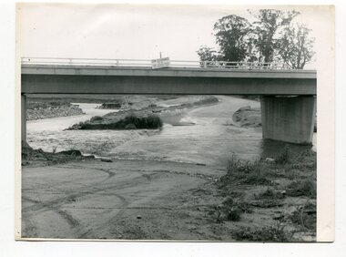
black and white photographs, October 22 1976
The road to Marlo was cut by flood waters from the Snowy River in two places. The road was closed when water flowed over Gilbert's Gulch (3243.1) The Snowy River broke its banks and flooded surrounding Orbost, Marlo, Lochend and Jarrahmond were isolated. The river bank at the bridge site was broken and filled with earth and rock fill. (3243.2) The new Snowy River Bridge was nearing completion when the river rose 7.2 metres causing erosion on the eastern bank. (3243.7) Contractors involved in the construction of the Princes Freeway and bridge were delayed by the flood waters. (3243.8) The 1976 flood at Orbost was a significant event which delayed the construction of the current Snowy River Road Bridge.These photographs record that event.Nine black / white photographs of flood waters across roads. orbost-flood-1976 snowy-river-bridge marlo-road-flood-1976 gilbert;s-gulch-flood -
 Orbost & District Historical Society
black and white photographs, February 17 1971
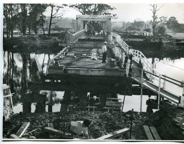
After the damage from the February 1971 floods at Orbost when the abutment to the Snowy River road bridge was washed away a Bailey bridge, portable, pre-fabricated, truss bridge, was put into place to ensure town access, the C.R.B. rebuilt the approach to the bridge driving new piles and constructing the Bailey bridge. They worked late into the night under flood lights to ensure the link from the Orbost township to the Princes Freeway would be open to traffic as soon as possible.These photographs are pictorial records of a significant event in the history of Orbost.Three black / white photographs of a Bailey bridge being erected across a river. 3245.1 and 3245.2 are the same. bailey-bridge orbost-snowy-river-bridge bridge-orbost -
 Orbost & District Historical Society
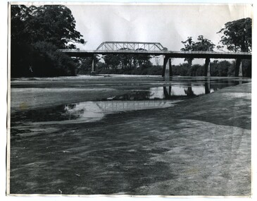
black and white photographs, 1937
These photographs are of the bridge across the Snowy River at Orbost which was replaced in 1976. This bridge over the Snowy River was opened on July 4 1922. It was constructed in 1922 alongside the previous suspension bridge. Its building was a combined effort of the Victorian Railways and the Country Roads Board at a cost of 35,000 pounds. It was replaced in 1976 by the present bridge after several major floods.This bridge was replaced in 1976 after several major floods. This is a pictorial record of that bridge.Three black / white photographs of a truss bridge across a river.bridge-snowy-river orbost-bridge-1937 -
 Orbost & District Historical Society
black and white photograph, January 1934
From The Argus (Melbourne) on January 10 1934 "Damage estimated at £500,000 has been caused by the floods in the Orbost district. No loss of life occurred, largely owing to the heroic efforts of rescue parties. Many families spent Monday night on the roofs of houses or in trees, surrounded by deep, rushing flood waters." This 1934 flood was devastating, destroying a section of the 1922 Orbost bridge - the centre span was washed away -. wrecking fences, bridges and roads, dumping silt and debris on the rich river flats and drowning cattle. This is a pictorial record of the 1934 flood, a significant event in the history of Orbost.A black / white photograph of floodwaters. In the middle of the water can be see debris including a large spoked wheel. In the background are houses and fences.on back - "near Hilyer's garage at foot of hill Main Street Caravan Park on right" on front at bottom left - "1934"orbost-flood-1934 flood-orbost -
 Orbost & District Historical Society
black and white photographs, January 1934
These are photographs taken during the 1934 flood at Orbost. From The Argus (Melbourne) on January 10 1934 "Damage estimated at £500,000 has been caused by the floods in the Orbost district. No loss of life occurred, largely owing to the heroic efforts of rescue parties. Many families spent Monday night on the roofs of houses or in trees, surrounded by deep, rushing flood waters." This 1934 flood was devastating, destroying a section of the 1922 Orbost bridge - the centre span was washed away -. wrecking fences, bridges and roads, dumping silt and debris on the rich river flats and drowning cattle.These photographs are pictorial records of the 1934 floods at Orbost, a significant event in the history of Orbost.Nine small black / white photographs of flood damage,3253.2 on back - "Waters rushing down Princes Highway and....of......where you see the waves" 3253.3 on back - "rushing flood waters over Lochiel Park Bridge approach at the rear of picture 1934"orbost-flood-1934 flood-orbost -
 Orbost & District Historical Society
black and white photograph, Howard D. Bulmer, first half 20th century
A new bridge over the Snowy River at Orbost was opened for traffic on June 20th 1922. It was intended as a road and rail bridge, and was again partly washed away by flood waters in 1934. After the end of the first World War the Victorian Railways considered an extension of the railhead across the river at Orbost, and in 1922 a new timber and steel girder structure, a joint Country Roads Board — Victorian Railways venture, was built and completed at a cost of £41,000 (the steel girders came from the Flinders Street viaduct reconstruction). Subsequently it was decided decided not to take the railway across the river, and the bridge was only used by road traffic. This is a pictorial record of an early bridge over the Snowy River at Orbost.A black / white postcard photograph of a bridge across a shallow river with men on horseback underneath.snowy-river-bridge -
 Orbost & District Historical Society
black and white photograph, 1934
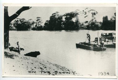
This photograph shows vehicles and people being ferried across the Snowy River during the 1934 flood. The Orbost punt was reinstated on a temporary basis following damage to the bridge. Damage estimated at £500,000 was caused by the 1934 floods in the Orbost district. This 1934 flood was devastating, destroying a section of the 1922 Orbost bridge, wrecking fences, bridges and roads, dumping silt and debris on the rich river flats and drowning cattle. The centre span of the Orbost Bridge was washed away.This is a pictorial record of the effects of the 1934 floods in the Orbost district.A large black / white photograph of a punt with a motor vehicle and people making their way across a river.on front - "On the Snowy 1934"snowy-river-orbost flood-1934 river-transport-punt -
 Orbost & District Historical Society
black and white photograph, first half 20th century
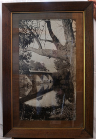
This is a bridge across the Snowy River at Orbost. This bridge was built in the 1920s as a road and rail bridge, and was partly washed away by flood waters in 1934. After the end of the first World War the Victorian Railways considered an extension of the railhead across the river at Orbost, and in 1922 a new timber and steel girder structure, a joint Country Roads Board — Victorian Railways venture, was built and completed at a cost of £41,000 (the steel girders came from the Flinders Street viaduct reconstruction). Subsequently it was decided not to take the railway across the river, and the bridge has only been used by road traffic.This is a pictorial record of an early bridge across the Snowy River at Orbost.A very large black / white photograph under glass in a timber frame. It is of a bridge across a river and is framed by trees.bridge snowy-river-bridge road-transport-orbost -
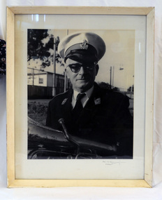 Orbost & District Historical Society
framed black and white photograph, mid - second half 20th century
This is a photograph of Mr Clem Heather, band leader. Clem Heather was a Forestry employee in Orbost, The Orbost Workers' Band was started in 1889 by Donald and Archie Munro. The band folded after the town was devastated by floods in 1893. Charles Spink reformed the group in 1905. It split in 1908 and the breakaway band was named the Orbost Workers Band. The two bands, The Orbost Workers and Orbost Town Band would often compete against each other. Eventually, in 1913, the two bands amalgamated to form the Orbost Municipal band. The old Orbost Municipal Band recorded its last meeting in 1941 -a lack of effort and membership. The new Orbost Municipal Band was restarted by Clem Heather (a previous member) on Wednesday 20th September, 1961 and continued into the late 1980s when lack of interest caused it to become defunct.This is a pictorial record associated with the Orbost Brass Band. The various Orbost bands over the years played a major role in community activities providing entertainment and musical experiences for the many membersA black / white photograph of a man in a brass band uniform. He is holding a brass instrument (French horn?). It is under glass in a white wooden frame.on front -????????? Orbostheather-clem orbost-brass-band music recreation -
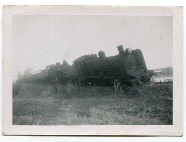 Orbost & District Historical Society
black and white photographs, 1950s
Dudley Charles Seymour Courtney , with a fellow worker, was trapped on the Orbost Raailwaay Station roof until rescued by an army duck. These photographs were his. He worked on the railway in Orbost from 1942 - 1952 approximately. During the 1952 flood nearly half of Orbost rail way station is washed away. The stationmaster and four members of his staff were rescued by police using army ducks.This is a pictorial record of a significant event in the history of Orbost.Nine small black / white photographs of a derailed train at a railway station. Derailed trucks and floodwaters can be seen. The photographs have a narrow white frame. Some are portrait and others landscape.on back of 3082.8 - hand-written in blue pen :"The floods worked the line from under the trucks in a couple of hours"floods-orbost orbost-railway-station rescue courtney-dudley-charles-seymour -
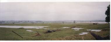 Orbost & District Historical Society
coloured photographs, Hogeman, Trudi, 2000 - 2010
These photographs are of floodwaters on the river flats of Orbost, near Gilberts Gulch on the Marlo Road showing large lumps of wood in the middle of the road and a red vehicle in the background. 3090.4 has been taken looking down onto theSnowy Rive from near Mitchells / Griebenows Road Newmerella.This is a pictorial record of a significant flood event in Orbost.Four panoramic colour photographs showing the aftermath of a flood. flood-orbost-2000s -
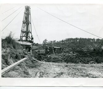 Orbost & District Historical Society
black and white photographs, 15th February 1971
... . They are also associated with the East Gippsland Railway. Orbost-flood ...The 1971 flood was the the worst flood on record. At Jarrahmond it was at least 11 metres and up to one and a half kilometres wide on the flats causing enormous damage to the flood plain. Records say that "The brown floodwater stain in Bass Strait could be seen from passing airliners." Considerable damage was done to railway infrastructure, roads and farms. More information from the APRIL, 2008 newsletter by John Phillips. (see orbosthistory.com.au) The railway line was destroyed and was not expected to be opened for a fortnight. Orbost was cut off by 50 square miles of Snowy River floodwater. These photographs are pictorial records of the 1971 floods which was a significant event in the history of Orbost. They are also associated with the East Gippsland Railway.Three black / white photographs of flood debris and flood waters near a railway line. 3102.l has a pile driver 3102.2 shows a gap in the viaduct and 3102.3 shows men with a tractor cleaning up the debris,3102.1 - on back - "1971 FLOOD REPAIRS TO ORBOST RAILWAY VIADUCT - 15th February 1971. Donated by Audrey Van Den Berg VRH 3693" 3102.2 - on back - " DAMAGE TO RAILWAY VIADUCT ACCUMULATED DEBRIS" 3102.3 - on back - "DAMAGE TO RAILWAY VIADUCT AT ORBOST. CLEAN UP BEGINS"orbost-flood-1971 orbost-viaduct-flood-damage orbost-railway